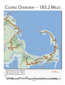
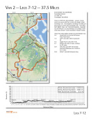
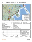
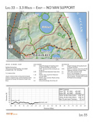
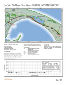
LEG 7 -- 7.8 MILES -- VERY HARD NO VAN SUPPORT 70.75' W LEG 7 -- 7.8 MILES -- VERY HARD Mayflower Church 207 Main Street Kingston, MA 02364 41"59'36 .35"N, 70'43'48.03 "W 11 AM- 9:30 PM Vans are not allowed on Powder Point bridge! SMILE MA· one of our charity groups, will have chicken salad and pasta salad along with other items available for a donation! BOO 700 600 ..., ':t=. 500 C: 0 400 · : ~ ~ 300 w 200 100 Exch 6 = 9' 0 0,0 0.5 1.0 1,5 2.0 2.5 ReeDOlr+,A RAG HAA 1 1 ~ CAPE COD 70.7' W 70.675' W 70.6 s· w LEG LEGEND : 0 0 Depart Exchange 6 heading south on Gurnet Road 70.65' W 70.625' W + VAN ROUTE: 0.0 Depart exchange 6 north on Gurne! toward Pine Point Rd for 1.2 miles 1.2 Continue ontoCanal Street for 0.7 miles 1.8 LEFT onto MA-139 E/Carewell St. for 3.1 miles 4.9 Slight RIGHT onto MA-14 W ier 0.8 miles 5.6 Merge LEFT onto MA-3 S for 4.6 miles 10.9 Exit 9 for MA-3A toward Kingston/N Plymoulh for 0.3 miles 10.3 RIGHT onto MA-3AN/Ma in St for0,5 miles 10.8 LEFT onto Main St for 0,2 miles 11.0 Exchange 7 is on the right 10.6 · w 70.625' W help) . LEFT onto Cross Street RIGHT onto Center 0 j z 'J 0.5 RIGHT 0N) to cross Powder Point Bridge 0.8 RIGHT 0N) to stay on Powder Point Avenue 7.6 7,7 7.8 LEFT into the church exchange . Police detail to assist. 1.9 LEFT (S) onto Washington Street. Road becomes Bay Road. 6.0 LEFT (S) onto Bay Street which becomes Landing Street 6.8 RIGHT (NW) onto Maple Street 7.2 LEFT (S) onto Summer Street/3A 7.5 RIGHT onto Green St (use cross walk just past Green to cross 3A and run back to Green. A Police detail will be there to GPS COORDS EXCH 6: 42.056, EXCH 7: 41.993, -70.6 47 -70.730 TOT A L ELEVATION Loss: -222 FT. TOT AL ELE VATION GAIN: 30 1 FT. NET ELEVATION CHANGE : 78 FT. Exch 7 = 88' 3.0 3.5 4.0 4.5 5,0 5.5 6.0 6.5 7.0 7.5 s.o 8.5 9.0 9,5 10.0 Distance (Miles) LEG 7
Purchased from Demo (abedemo.tizrapublisher.com) for the exclusive use of unknown.
© 2026 Demo. Please report unauthorized use to pirate@tizra.com