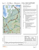
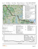
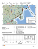
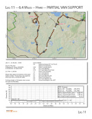
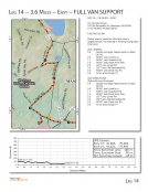
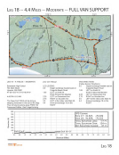
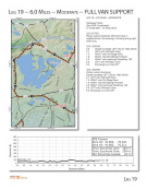
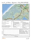
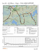
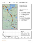
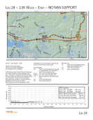
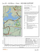
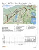
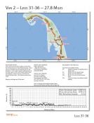
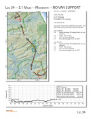
LEG 1 5.3 MILES 70.875 ' W 70.875° W 800 700 600 ~ 500 C 0 400 ·.::: ro 300 (I/ w 200 100 Start== 2' 0 0.0 - 0.5 -- ~ ..... RAGNAR 11 ~ CAPECOO 1.0 1.5 2.0 ... 2.5 MODERATE -- FULL VAN SUPPORT 70.85 ° W 70.BS' W - 3.0 3.5 N j z :',, N N st + LEG 1 •• 5.3 MILES·· MODERATE Southshore Baptist Church 578 Main Street, Hingham, MA02043 GPS: 42'13 '3.72"N 70'53'5 .03"W 5:15 AM - 4:45 PM Start Line is located at Nantaske t Beach. Runners should stay on the sidewalk for this ent ire leg. There are police to help at some of the larger crossings . At the sma lier crossings runners w ill use the 'wa lk' lights and cross walks to safely navigate cross ings. Vans will detour onto Middle to avo id backups at the Main/Free intersect ion and will enter/ex it the exchange on Free Street . LEG LEGEND : 0.0 Depart exchange head ing south on Nantasket Avenue 1.0 Continue onto Hull Street/Highway 228 2.2 3.7 3.9 4.0 4.3 4.5 5.3 Hull St. will become East St. East will then become Leavitt St. LEFT onto Short St. Continue STRAIGHT onto Main Street/H ighway 228 at intersection At the intersection of Pleasant St turn Left to use cross wa lk to run against traffic on Main St. on sidewalk. Officer detail will assist. Continue on 228. Arrive at Exchange 1 VAN ROUTE: 0.0 Start heading south on NantasketAvenue 1.0 Continue onto Hull Street/Highway 228 2.2 Hull St. will become East St. 3.7 3.8 4.0 4.3 5.1 6.0 East will then become Leavitt St. Turn Left onto Short St. Turn Left onto Middle Street Middle becomes Union(after you cross Pleasant) Cont inue straight onto Free Street where Union turns left. Right turn into Exchange . GPS COORDS START: 42.271, -70.857 EXCH 1: 42.217 , -70.885 TOT A L ELEVATION Loss: -158 FT. TOTAL ELEVATION GAIN: 198 FT. NET ELEVATION CHANGE: 40 FT. Exch 1 -42' 40 45 ~o ~5 Distance (Miles) 6.0 6.5 7.0 7.5 8.0 8.5 9.0 LEG 1
Purchased from Demo (abedemo.tizrapublisher.com) for the exclusive use of unknown.
© 2026 Demo. Please report unauthorized use to pirate@tizra.com