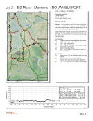
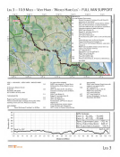
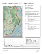
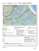
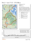
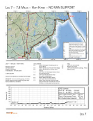
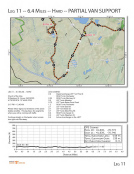
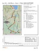
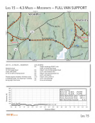
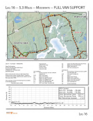
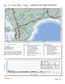
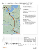
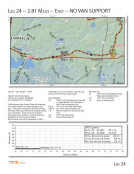
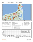
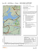
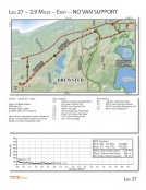
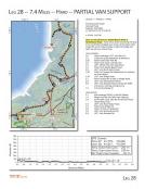
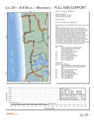
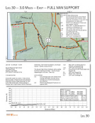
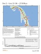
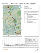
LEG 2 -- 5.0 MILES d 10.a1sw · \ I 70.875' W MODERATE 10as· . w 70.85° W NO VAN SUPPORT LEG 2 -- 5.0 MILES -- MODERATE Wompatuck State Park Transfer Station (see GPS coordinates) 42°12'4.96"N 70°50'37.45"W 6:00 AM - 5:00 PM Runners-The first portion of leg 2 continues on 228/Main St and crosses several times to keep on the sidewalk. Please use caution when crossing roads and intersections. Use all cross walks and obey the 'walk' signal lights. Vans-Please follow Free to Union and head directly to the exchange. You will see runners the last 0.75 miles of this leg. Please remember this is a non-support leg and continue to the exchange. LEG LEGEND: 0.0 Depart Exchange 1 heading South on 228/Main 1.7 LEFT onto Prospect Street 2.5 LEFT onto Charles Street 3.3 RIGHT onto S. Pleasant., then continue through the gate to enter the park. 4.2 RIGHT onto Union Street 5.0 LEFT into Exchange 2 (Wompatuck State Park Transfer Station) VAN ROUTE: 0 0 Vans take a LEFT out of the exchange onto Free Street. 0.8 Sharp RIGHT turn onto Union Street. Follow Union right into Wompatuck State Park. 2.7 LEFT onto Beechwood and Right into exchange 2 800 ,---- ----------:--,---,----,- ::: ============:: -, 700 600 ¢: 500 C 0 400 · ::, ~ 300 (lJ iii 200 .. GPS CooRDS EXCH 1: 42.217, EXCH 2: 42.201, -70.885 -70.8 43 TOTAL ELEVATION Loss: -175 FT. TOTAL ELEVATION GAIN: 256 FT. NET ELEVATION CHANGE: 81 FT. 100 Exch 1 = 42' ~..,,,_-----"'...---.._~----~ Exch2=123 ' 0-l--==--~--~-~--~-~-~~-~-~--~-~--~-~--~-~--~-~--~--1 0.0 0.5 1.0 1.5 2.0 2.5 3.0 3.5 --I~ ~ ..... RAGNAR l CAPE COO to ts 50 55 ~o Distance (Mi les) 6.5 7.0 7.5 8.0 8.5 9.0 LEG 2
Purchased from Demo (abedemo.tizrapublisher.com) for the exclusive use of unknown.
© 2026 Demo. Please report unauthorized use to pirate@tizra.com