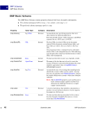
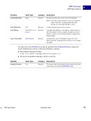
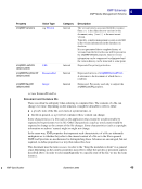
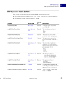
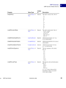
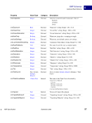
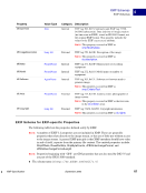
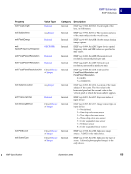
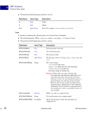
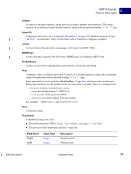
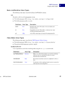
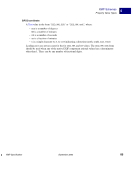
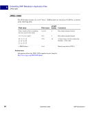
XMP Specification September 2005 69 XMP Schemas EXIF Schemas 4 exif:GPSTrackRef Closed Choice of Text Internal GPS tag 14, 0x0E. Reference for movement direction: T = true direction M = magnetic direction exif:GPSTrack Rational Internal GPS tag 15, 0x0F. Direction of GPS movement, values range from 0 to 359.99. exif:GPSImgDirectionRef Closed Choice of Text Internal GPS tag 16, 0x10. Reference for movement direction: T = true direction M = magnetic direction exif:GPSImgDirection Rational Internal GPS tag 17, 0x11. Direction of image when captured, values range from 0 to 359.99. exif:GPSMapDatum Text Internal GPS tag 18, 0x12. Geodetic survey data. exif:GPSDestLatitude GPSCoordinate Internal GPS tag 20, 0x14 (position) and 19, 0x13 (North/South). Indicates destination latitude. exif:GPSDestLongitude GPSCoordinate Internal GPS tag 22, 0x16 (position) and 21, 0x15 (East/West). Indicates destination longitude. exif:GPSDestBearingRef Closed Choice of Text Internal GPS tag 23, 0x17. Reference for movement direction: T = true direction M = magnetic direction exif:GPSDestBearing Rational Internal GPS tag 24, 0x18. Destination bearing, values from 0 to 359.99. exif:GPSDestDistanceRef Closed Choice of Text Internal GPS tag 25, 0x19. Units used for speed measurement: K = kilometers M = miles N = knots exif:GPSDestDistance Rational Internal GPS tag 26, 0x1A. Distance to destination. exif:GPSProcessingMethod Text Internal GPS tag 27, 0x1B. A character string recording the name of the method used for location finding. exif:GPSAreaInformation Text Internal GPS tag 28, 0x1C. A character string recording the name of the GPS area. Property Value Type Category Description
Purchased from Demo (abedemo.tizrapublisher.com) for the exclusive use of unknown.
© 2026 Demo. Please report unauthorized use to pirate@tizra.com