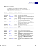
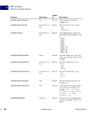
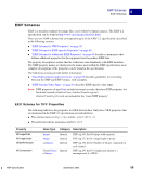
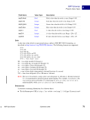
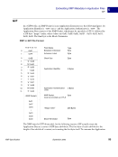
68 September 2005 XMP Specification XMP Schemas EXIF Schemas 4 exif:GPSAltitudeRef Closed Choice of Integer Internal GPS tag 5, 0x5. Indicates whether the altitude is above or below sea level: 0 = Above sea level 1 = Below sea level exif:GPSAltitude Rational Internal GPS tag 6, 0x06. Indicates altitude in meters. exif:GPSTimeStamp Date Internal GPS tag 29 (date), 0x1D, and, and GPS tag 7 (time), 0x07. Time stamp of GPS data, in Coordinated Universal Time. NOTE: The GPSDateStamp tag is new in EXIF 2.2. The GPS timestamp in EXIF 2.1 does not include a date. If not present, the date component for the XMP should be taken from exif:DateTimeOriginal, or if that is also lacking from exif:DateTimeDigitized. If no date is available, do not write exif:GPSTimeStamp to XMP. exif:GPSSatellites Text Internal GPS tag 8, 0x08. Satellite information, format is unspecified. exif:GPSStatus Closed Choice of Text Internal GPS tag 9, 0x09. Status of GPS receiver at image creation time: A = measurement in progress V = measurement is interoperability exif:GPSMeasureMode Text Internal GPS tag 10, 0x0A. GPS measurement mode, Text type: 2 = two-dimensional measurement 3 = three-dimensional measurement exif:GPSDOP Rational Internal GPS tag 11, 0x0B. Degree of precision for GPS data. exif:GPSSpeedRef Closed Choice of Text Internal GPS tag 12, 0x0C. Units used to speed measurement: K = kilometers per hour M = miles per hour N = knots exif:GPSSpeed Rational Internal GPS tag 13, 0x0D. Speed of GPS receiver movement. Property Value Type Category Description
Purchased from Demo (abedemo.tizrapublisher.com) for the exclusive use of unknown.
© 2026 Demo. Please report unauthorized use to pirate@tizra.com